Trip report part 5
Hawai'i Volcanoes National Park
Note: there are several links in this report. If you have any interest at all in the Hawai'ian volcanoes or just want to know more about the place that I visited, please take the time to explore them. Also, you can click on any of my photos to view them on Flickr. And finally, you can check out my
Hawai'i Flickr album, which is where you can find my growing collection of photos from this trip.
On Thursday (August 24, 2017, for those keeping track), we had booked a tour that would take us up Mauna Kea to see the astronomical observatories at the summit. We chose a daytime tour over a night tour because we would be able to visit the inside of one of the observatories. Unfortunately, before we even left Kona on Wednesday afternoon, we learned that we were the only ones to book the tour on that day, and the company requires a minimum of four. So we were out of luck. The tour was available on other days, be we already had other plans on those days.
So rather than getting up at 5 am to drive to Hilo, we decided to sleep in on Thursday. (It wasn't a hard decision, after getting up at 2 am to drive to Portland on Wednesday morning.) Once we were up and awake, we headed up the hill (all 4000 feet of it) from our sea-level condo to
Hawai'i Volcanoes National Park. We had no firm plans, we just wanted to see whatever we had time to see.
Our first stop was the visitor center. It's relatively small, but the displays were interesting. We listened to a ranger give a short "things to do" presentation and picked up a couple of trail guides from the gift shop. Park trivia: Hawai'i Volcanoes National Park was created in 1916, and had just observed its 101st birthday.
Our first hike of the day was a short jaunt to the
sulphur banks. This is an area where volcanic gases loaded with sulphur dioxide seep up through the rock, killing the plants and leaving behind sulphur deposits.
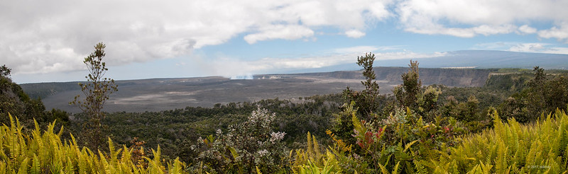
This is what we saw when we arrived at the banks:
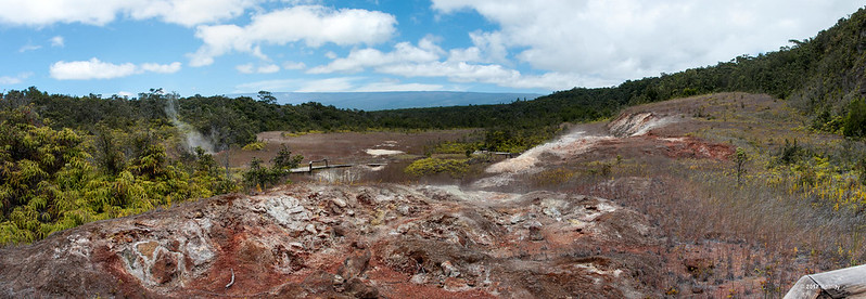
Kilauea Sulphur Banks Panorama
You can see the steam rising in several areas and the effect it has on the vegetation. Here's a closer view of the area on the right of the panorama.
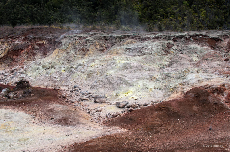
Sulphur Bank
There is a boardwalk through the area to provide a safe pathway. As you know, steam is hot!
Close up view of sulphur deposits.
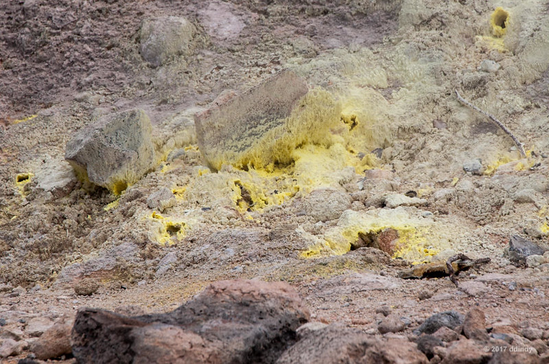
Deposits at the Sulphur Bank
After enjoying the view (but not the smell) of the sulphur banks, we stopped by
Volcano House, the hotel within the park. If you book far enough in advance, you can have a room that overlooks the Kilauea crater.
We then drove around the crater to the
Jaggar Museum, another small visitors center with interesting exhibits and an observation deck overlooking Kilauea caldera.
Kilauea Caldera Panorama
The mountain visible on the right is Mauna Loa volcano, also part of the national park.
In the center, you can see Halema'uma'u crater, which became active in 2008. It now contains the largest lava lake in the world. Unfortunately, the lava is too far below the edge of the crater so be seen from publicly accessible areas. If you're interested in a closer view, the
Hawaiian Volcano Observatory has a couple a
webcams that offer a good view of this and other interesting sites.
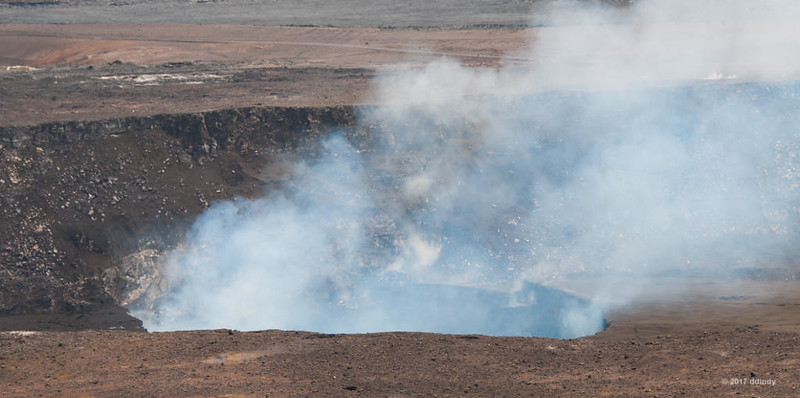
Halema'uma'u by Day
Looking over the trail map, we decided to do the
Kilauea Iki hike. The rim of the crater is approximately 3900 feet above sea level, but the 4-mile hike includes a 400-foot descent to the floor of the crater (and a corresponding 400-foot climb back out). The crater was flooded with lava during an
eruption in late 1959.
(If you like, you can download the
Kilauea Iki Trail Guide. It contains lots of interesting information, and I will be referencing points along the trail map as shown on pages 10 and 11.)
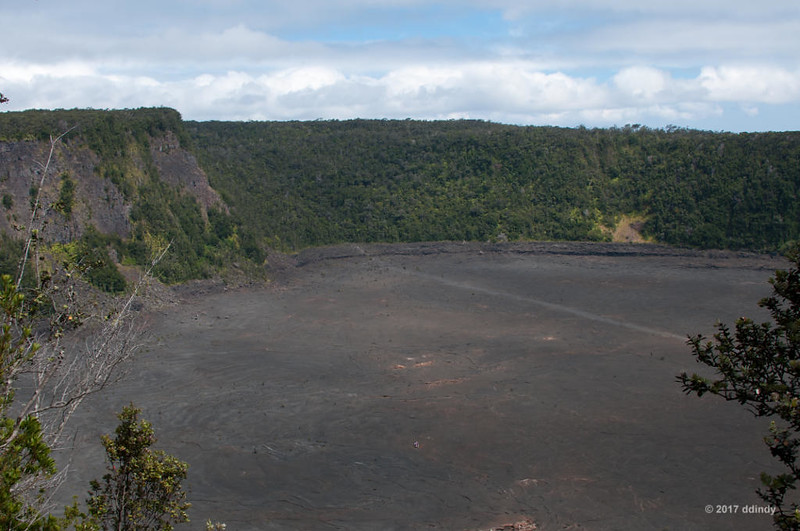
Looking in a westerly direction from the trailhead, you can see the floor of the Kilauea Iki ("little Kilauea") crater. On the left is the cinder cone created by the Pu'u Pua'i vent, the source of the lava. Behind Pu'u Pua'i, you can see Halema'uma'u smoking from with the big Kilauea crater.
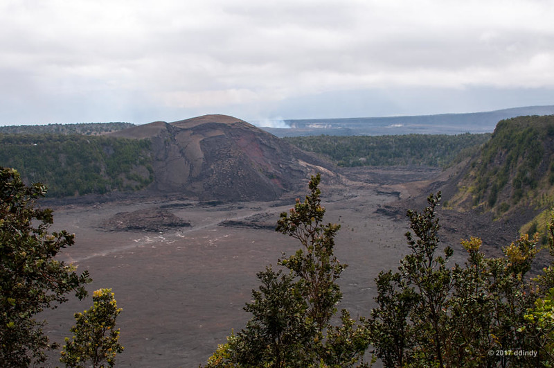
Kilauea Iki Western View
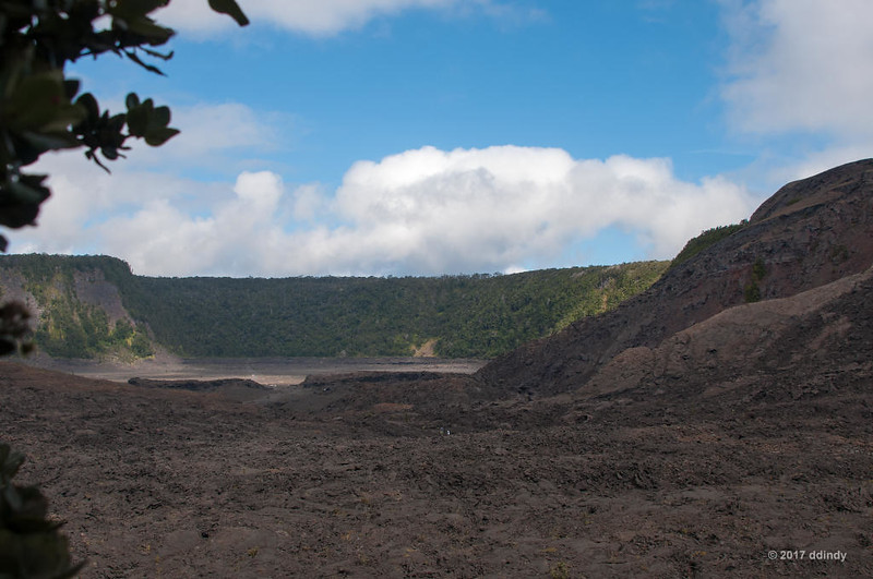
Looking in the opposite direction at trail stop 1, we can see the eastern end of the crater. You can see the trail across the lava. Around the edge of the basin, there is a sloping bank of lava. This "bathtub ring" was created as the hot lava cooled and shrank, something that is still happening today. The upper edge of the ring marks the high point of the lava before shrinking began.
Kilauea Iki Eastern View
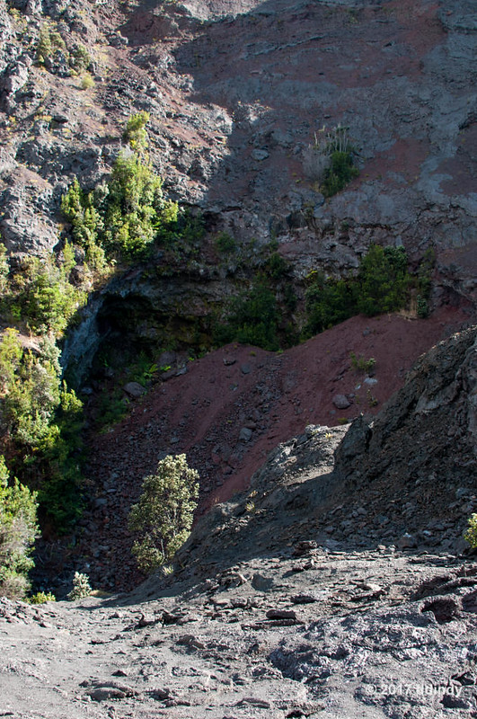
Near trail stop 3, we get a good view of the Pu'u Pua'i vent. The area that looks like a cave blocked by a big red rock is where the lava emerged. It's pretty obvious where the near side of the cinder cone has worn away over the years. Note the group of hikers along the trail near the bottom of the photo, which gives you an idea of the scale.
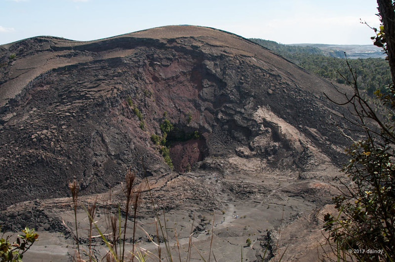
Pu'u Pua'i
After a pleasant hike through the forest, we took a series of switchbacks with steps carved into the ground, dropping 400 feet to the crater floor. We're standing at the top of the bathtub ring here, looking across very rugged terrain. You can also see hikers in this scene. This is trail stop 7.
On the Bathtub's Rim
Despite the seeming desolation on the crater floor, life is returning. Ohi'a trees such as these, along with ferns, are the first signs of life among the lava.
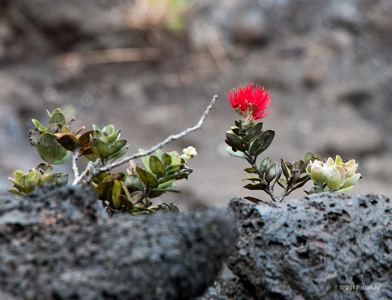
Ohi'a Color
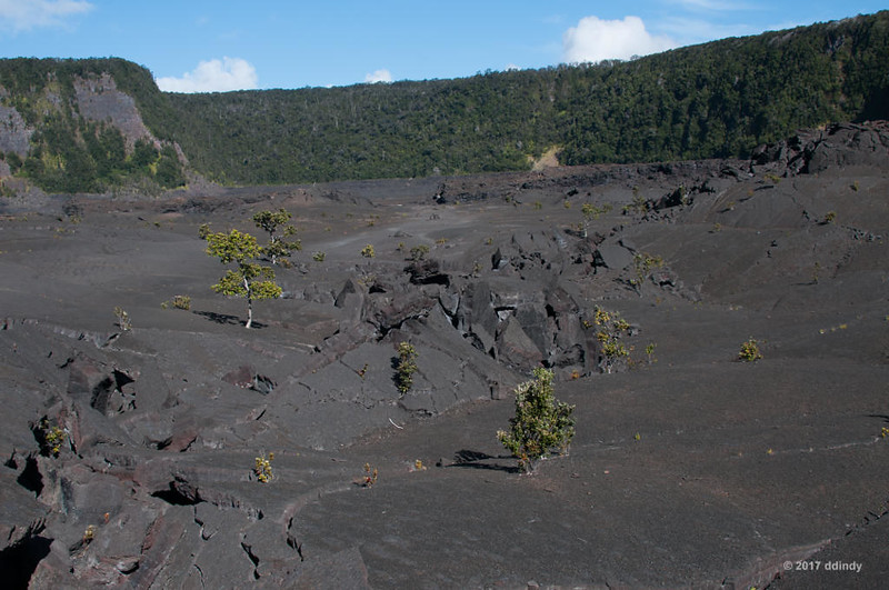
This trail has a difficulty rating of "moderate to challenging," and this view from trail stop 8 shows you one of the reasons. Most of what you see in the foreground is lava that was originally part of the cinder cone. Time, weather and gravity all contributed to it falling down onto the crater floor.

Rough Going
Here is a close-up view of the sealed up vent at the base of the cone, at trail stop 9. You wouldn't want to be here when lava was spewing hundreds of feet into the air.
Vent Plug
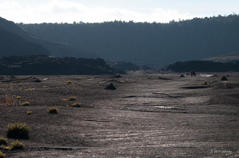
Once we got past the source of the lava, the crater floor smoothed out considerably. Between trail stops 11 and 12 there were several areas of broken lava like this, probably caused when a large chunk of hardened lava from an earlier eruption stuck up through the receding lava.
Broken Terrain
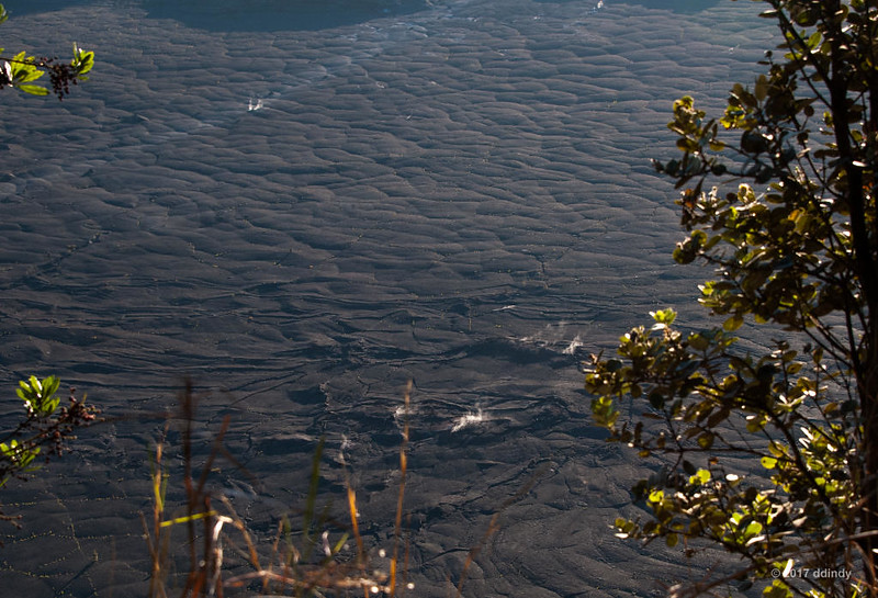
Looking back the way we came from trail stop 13, lit by the afternoon sun, the relative smoothness of the crater floor is obvious. Also obvious is one of the many steam vents, created when rainwater seeps down and finds still-hot rock.
Kilauea Iki Looking Back
The climb back up to the rim was heavily forested, with few good photo spots. On the home stretch, almost back to our starting point, I grabbed this shot of the crater floor showing several steam vents. The low sun angle really made them stand out.
Late Afternoon Steamers
Thus ended our first full day in the Aloha state. Once back at the condo, we went to bed early because Friday was going to be a big day with another too-early start.
Next: Things get hot!


 Total Eclipse 11:33:58 am