Best vacation ever!

Discussion in 'Non Disney Photos / Mobile Phone Photos' started by ddindy, Sep 13, 2017.

  1. ddindy

    ddindy Member Staff Member

    Trip report part 6

    Things Get Hot!

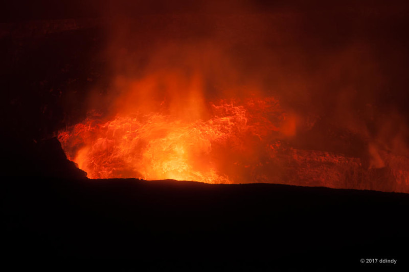
    We're up to Friday, August 25, 2017. We had booked an early-morning lava hike with Epic Lava. That meant getting up at 2 am and driving for an hour to the town of Kea'au where we were to meet our guide at 4 am. On the way, we passed near Kilauea where the red glow from Halema'uma'u crater was clearly visible. I wanted to stop for a photo, but decided it would be better to wait until later in the trip.

    Our guide, Yvonne Baur, met us at the designated location. Yvonne is originally from Germany and spent many years in Utah before moving to Hawai'i. She's also quite a good photographer. (More on that in part 8.) We were the only people on the morning tour, which meant we would get all of the attention. We followed Yvonne on the 30-minute drive to Kalapana, where the public road ends and the emergency access road begins. Kalapana was covered by lava in 1990. In the wake of that, there is a parking area and many temporary bicycle rental businesses (for people who don't want to hike to the end of the access road). As we neared the town, we could see what looked like street lights on top of a hill. But those weren't street lights. What we were seeing was lava pouring over the edge of Pulama pali. (Pali is the Hawai'ian word for a steep slope or cliff.) I took that as a good sign.

    We parked our car in the Kalapana parking area (really just a wide spot in the road) and transferred to Yvonne's car to drive another mile up the road. The tour company pays a homeowner a small fee to park at the end of their driveway, a much-appreciated saving of two miles of hiking.

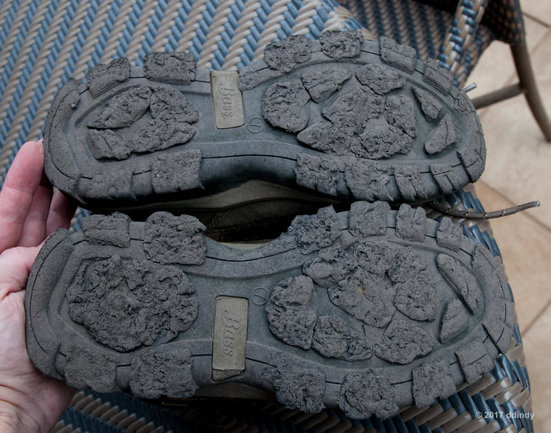
    The tour company provides all hikers with a small backpack with water, snacks, gloves, a rain poncho and a flashlight. The gloves were for protection in case of a fall in the lava field. Lava can be sharp, thanks to a high silica content, so a fall could be mean a painful hike back. On this day I made a few slips, but fortunately no falls.

    We started the hike around 5 am. Why hike in the morning? The lava field is basically a black surface. Imagine an asphalt parking lot on a sunny day. Would you rather walk on that in the morning, before the sun heats it up, or in the afternoon, after it has been baking in the sun all day? That's why a morning hike is better. Plus, if you do it soon after arriving in Hawai'i, your body hasn't had a chance to shift to Hawai'ian time. In the summer, Hawai'i is six hours behind Eastern time. (It's only five hours different in the winter, since Hawai'i does not observe Daylight Saving Time.) I kept telling myself that even though it's 5 am in Hawai'i, it's 11 am back home. It didn't help.

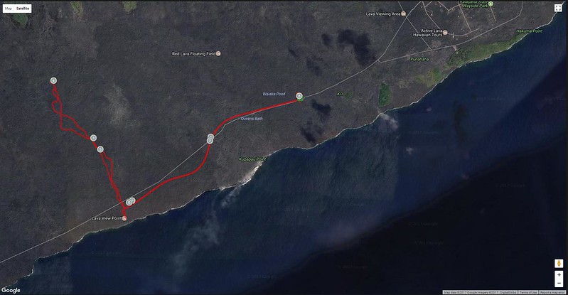
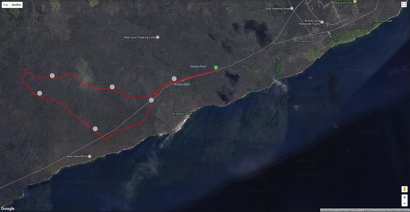
    Enough trivia. We hiked two miles along the gravel access road in the dark. For the first half mile, we were instructed to stay quiet, as we were passing several houses and we didn't want to disturb the residents. On the return hike, in daylight, we saw that the "houses" were several very small (one might even say tiny) buildings sitting on the lava. Not anything like what I had imagined in the dark. It's probably the perfect place for someone who wants to get away from it all.

    Along the way we passed a couple of locked gates that prevent people from driving down the road. Hikers and bicycles are free to pass. The second gate marked the entrance to Volcano National Park, and is the site of the only comfort facilities (porta-potties) on the hike.
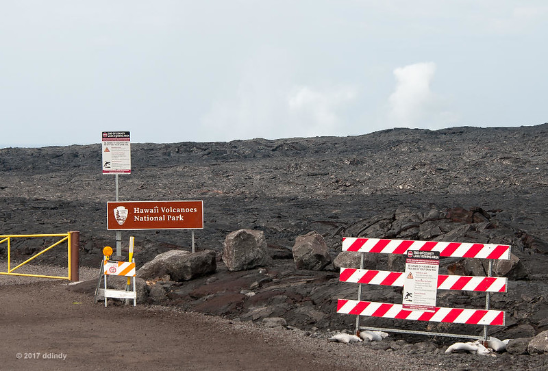
    [​IMG]
    Park Back Entrance


    After two miles we reached the "end" of the gravel road. It was blocked at this point due to the current path of the 61G flow from Pu'u O'o to the ocean. At this point, my sister, who had a cataract in one eye that greatly hampered her depth perception, realized that hiking over the lava was going to be difficult, if not impossible. She reluctantly decided to stay put while Yvonne and I headed off in search of lava. Fortunately, it was going to be a cloudy day, so she wouldn't have to worry about the heat.

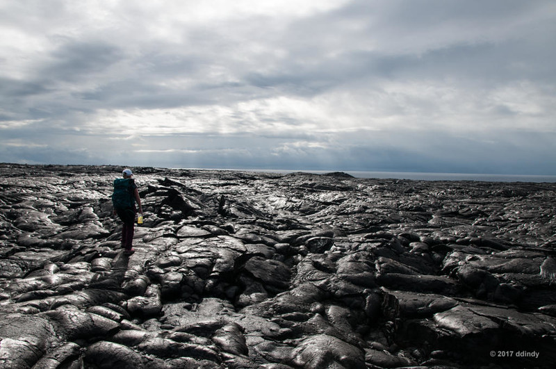
    We turned inland and hiked across the lava field for another two miles. Thanks to many layers of lava over the past 35 years, the hike is far from easy. There's as much up-and-down as there is horizontal progress.
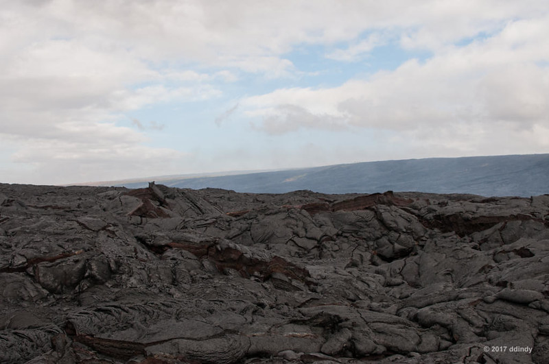
    [​IMG]
    Challenging Terrain


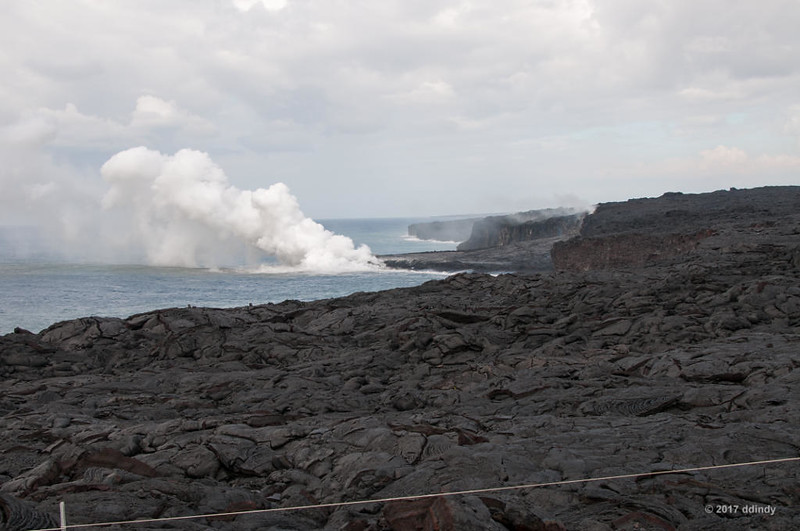
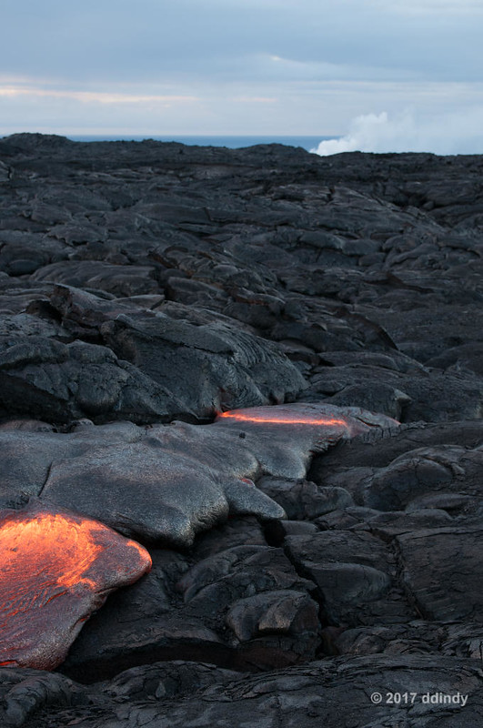
    I could see Pulama pali in the near distance with several plumes of smoke indicating lava movement.
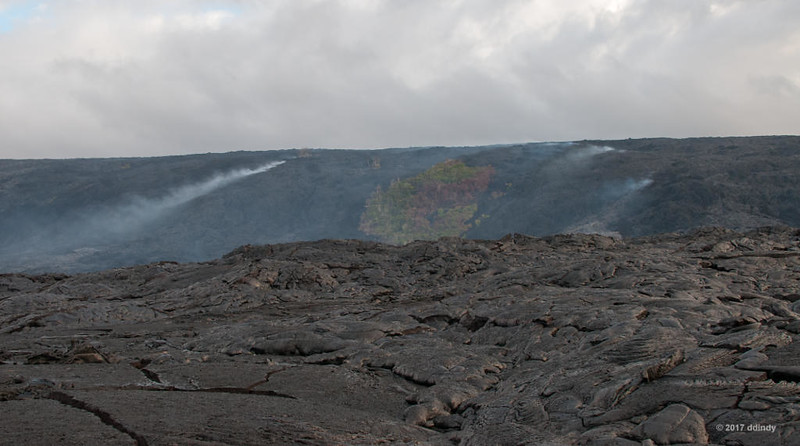
    [​IMG]
    Smoke on the Pali


    Surprisingly, there were a few areas which had still not been covered with lava.
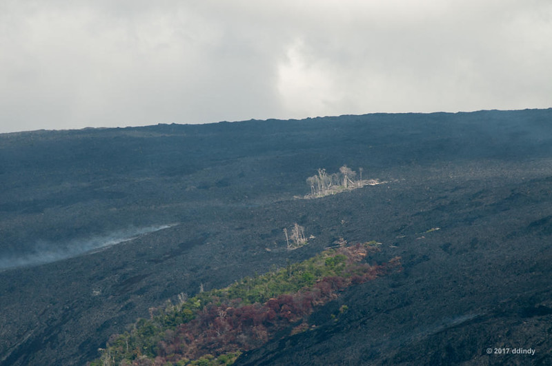
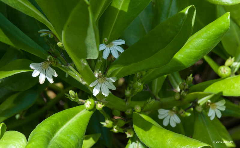
    [​IMG]
    Surviving Pele


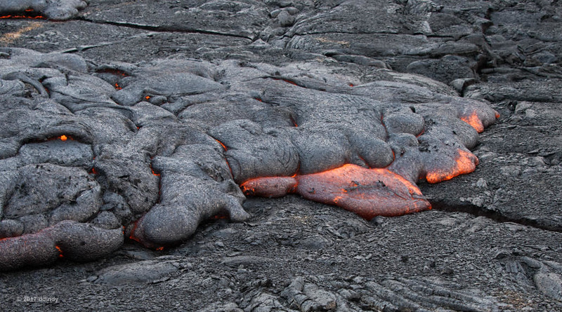
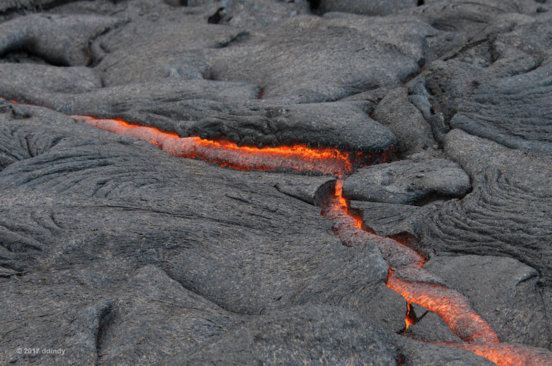
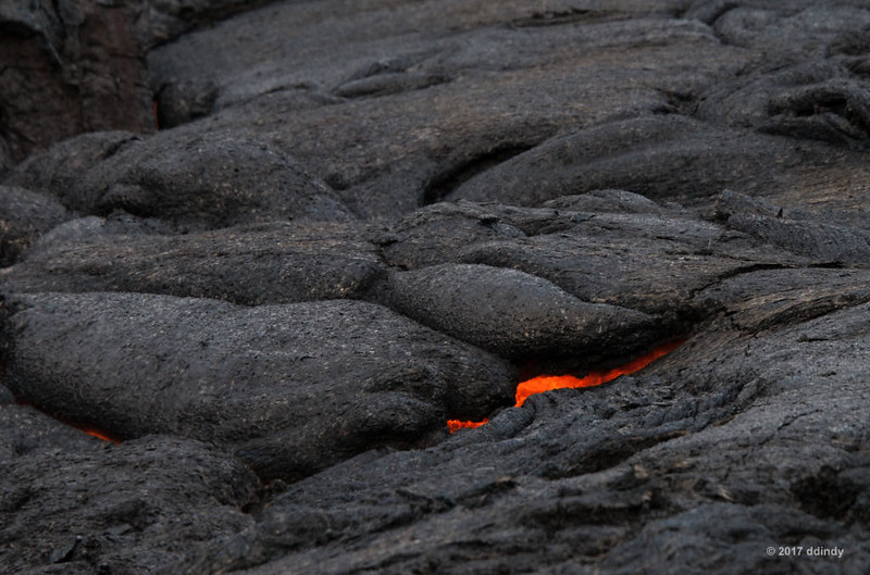
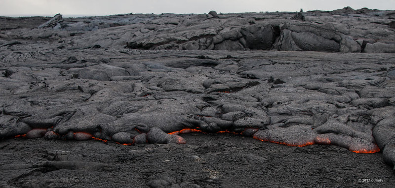
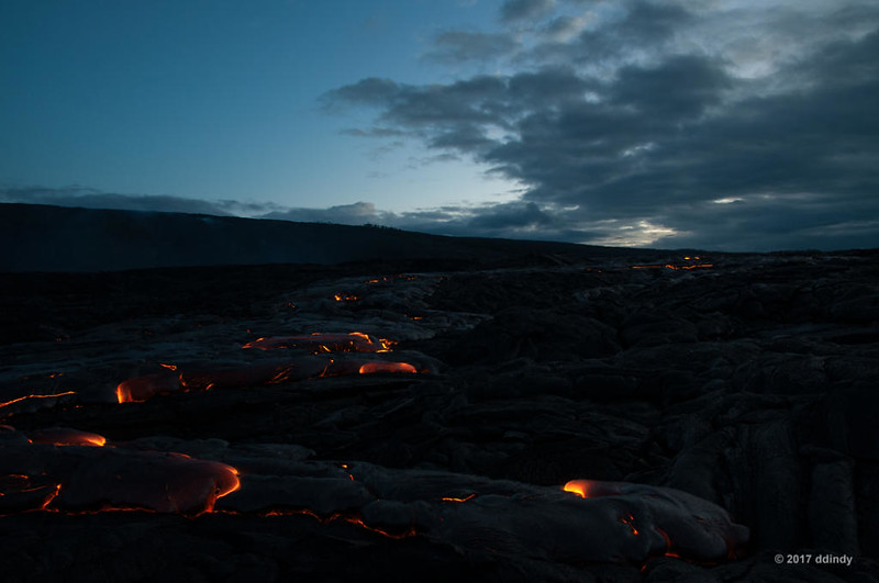
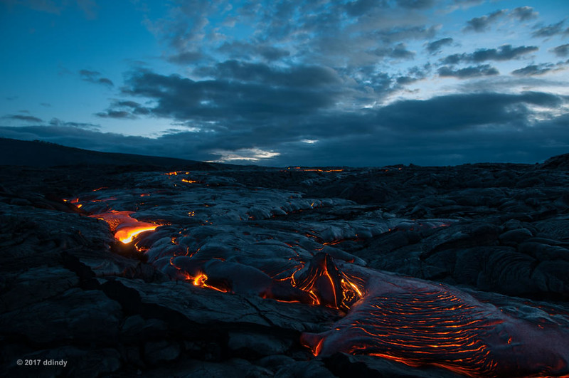
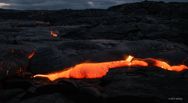
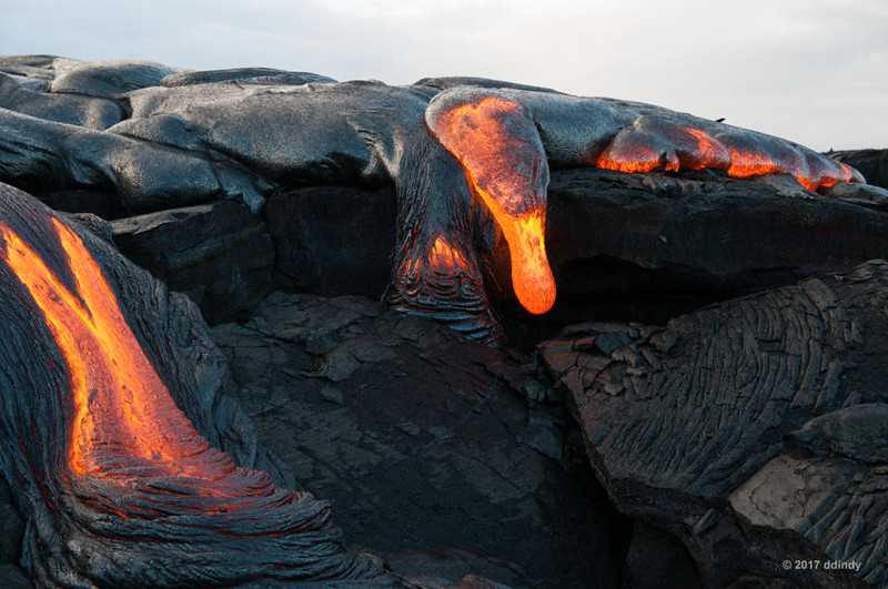
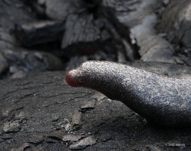
    Eventually, I started to feel some heat coming up from the ground. I asked "Is it just me or is it getting warmer?" Sure enough, as we crested the next hill, there it was: actual hot, glowing, moving lava.

    [​IMG]
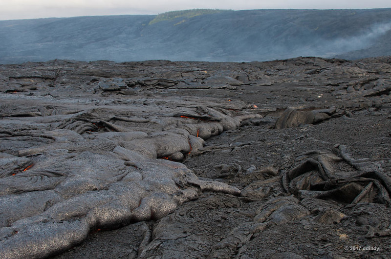
    Lava Hike 1, 6:45 am


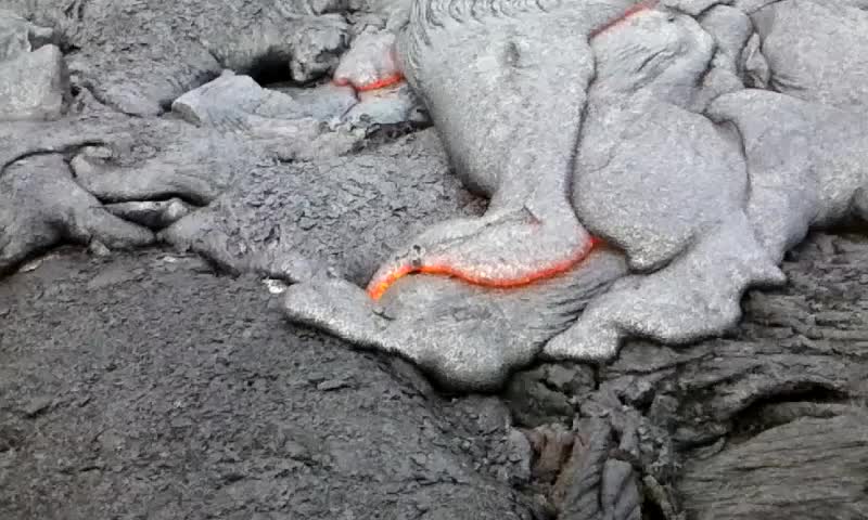
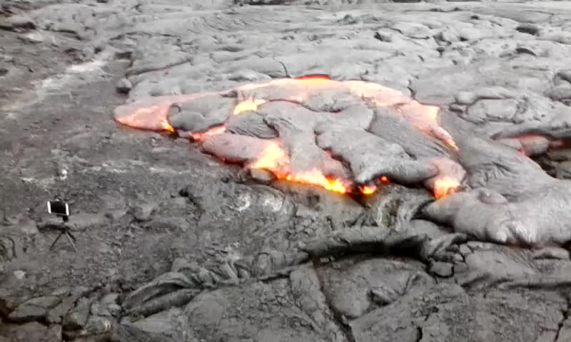
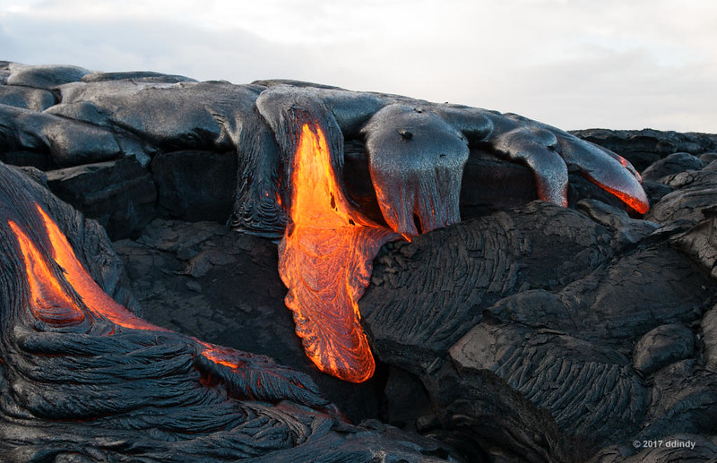
    Yvonne uses her phone to make time-lapse videos of the lava. Since she sets it up so close, the video ends when the phone overheats and shuts down. She has to take it away to cool off before shooting another.

    [​IMG]
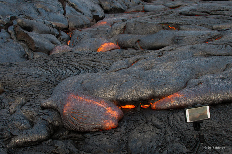
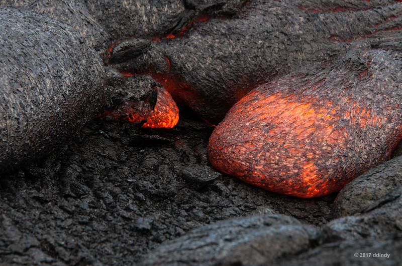
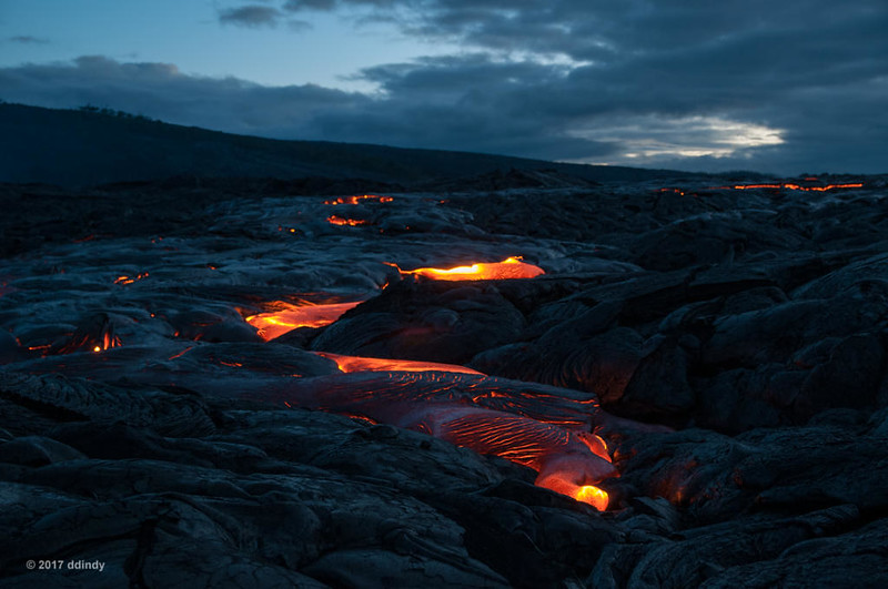
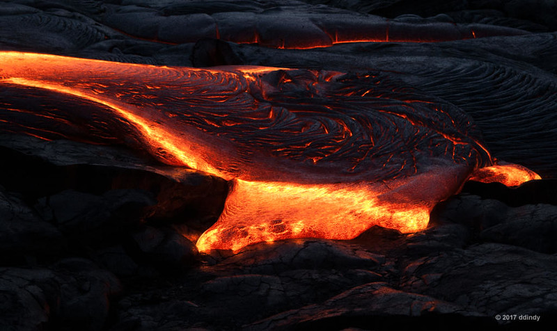
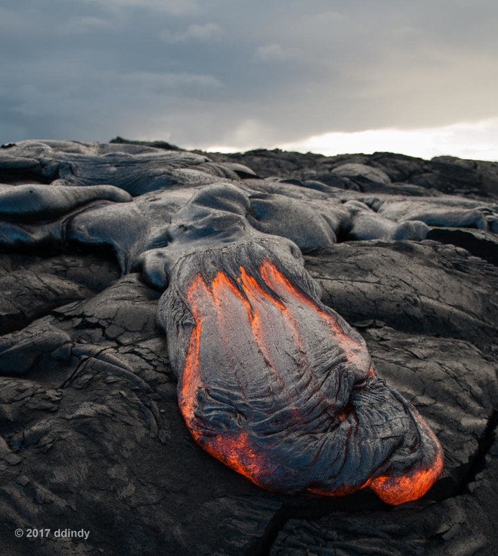
    Lava Hike 1, 6:44 am


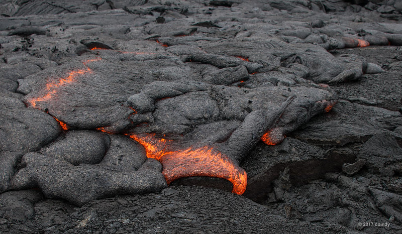
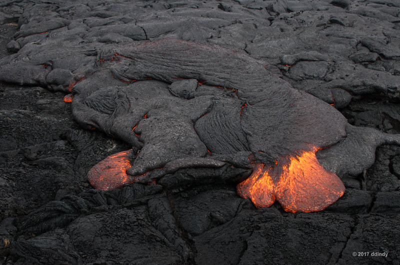
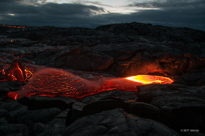
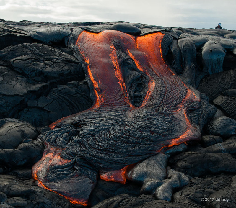
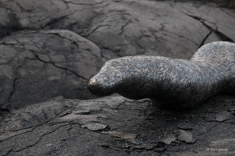
    The terrain in the area was relatively flat, so the lava moved very slowly. Actually, ooze is probably the correct word to describe the motion. There was no threat of being overrun by onrushing lava. It was relatively quiet, but the hot lava made a sort of sizzling sound, like meat cooking on a grill. (Click the photo below to view the video.)

    [​IMG]
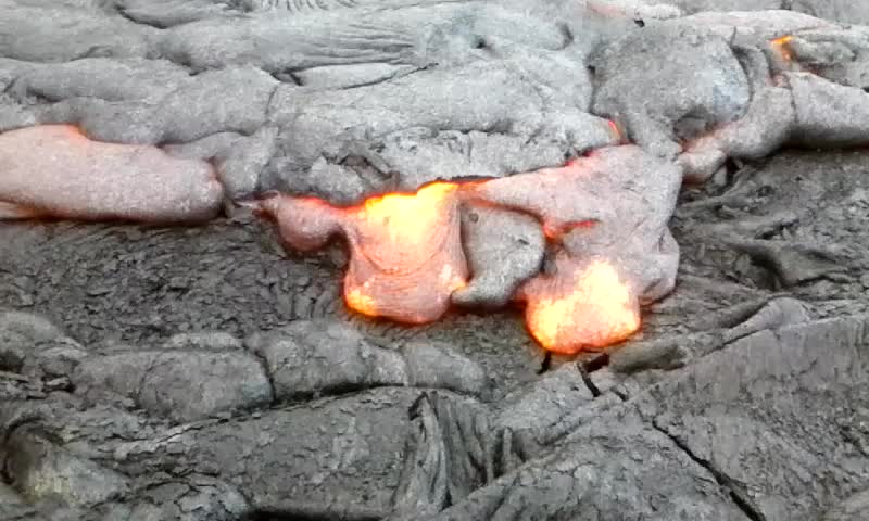
    Lava hike 1 video, 6:58 am


    [​IMG]
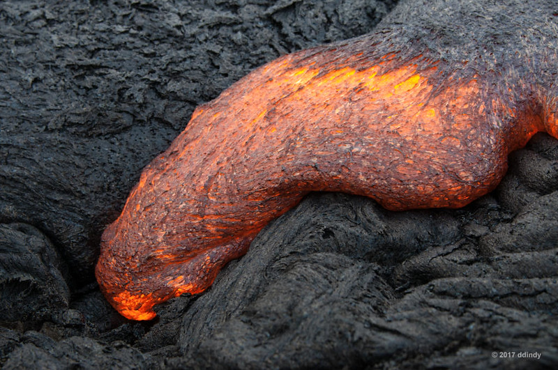
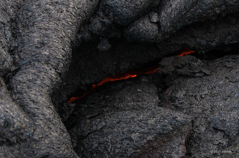
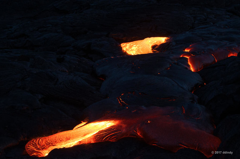
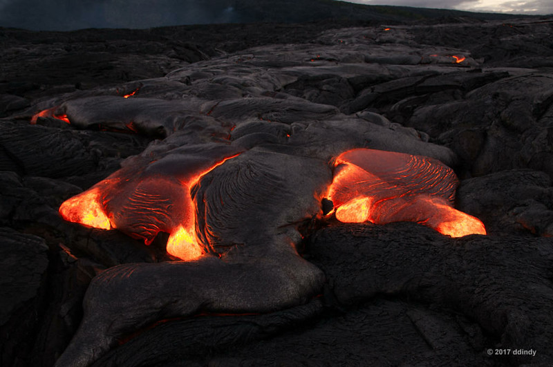
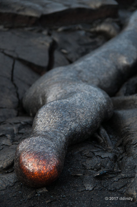
    Lava Hike 1, 6:49 am


    [​IMG]
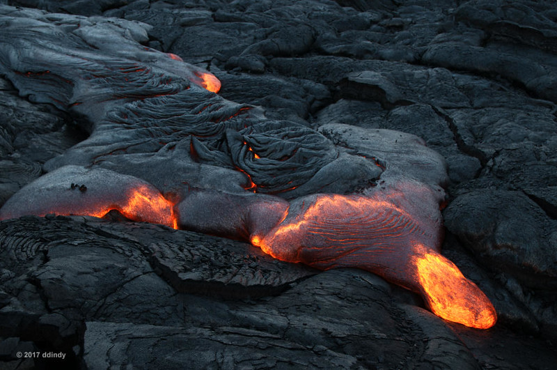
    Lava Hike 1, 6:50 am


    [​IMG]
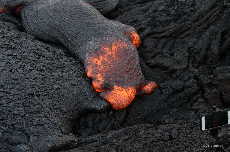
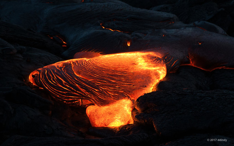
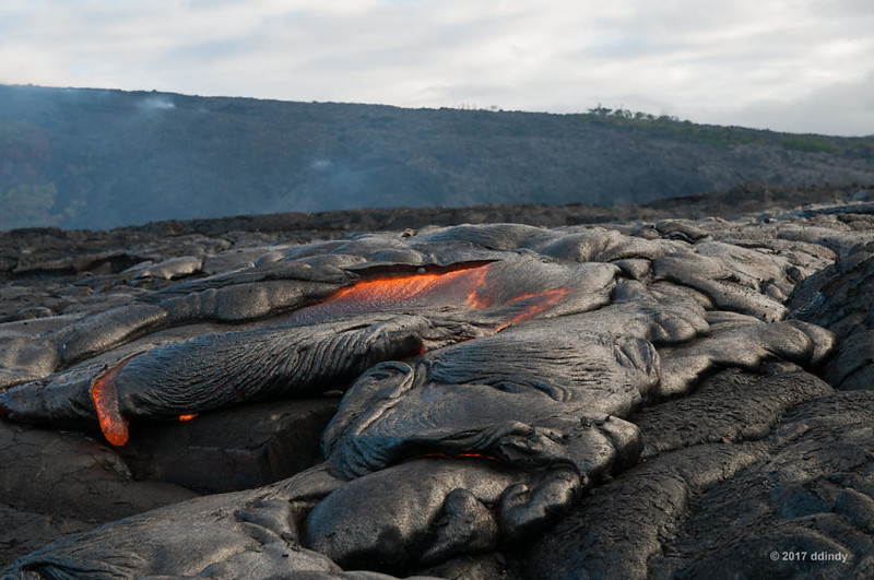
    Lava Hike 1, 6:52 am


    [​IMG]
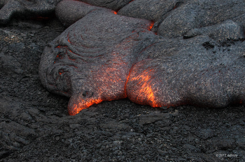
    Lava Hike 1, 6:53 am


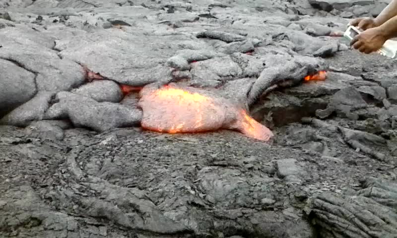
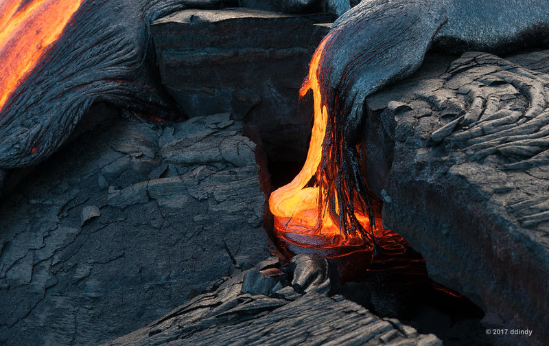
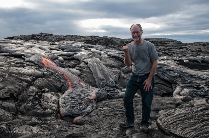
    Here I am taking the photo above. How hot was it? Lava like this is over 1000 degrees. My forearms felt like they were next to a hot fire. (I'm sure @gary can relate to that.) This was about as close as I could get for any length of time. On the plus side, after this, taking food out of a hot oven doesn't phase me any more.
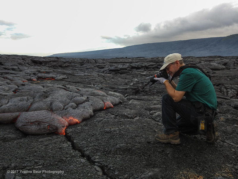
    [​IMG]
    Getting Toasted


    [​IMG]
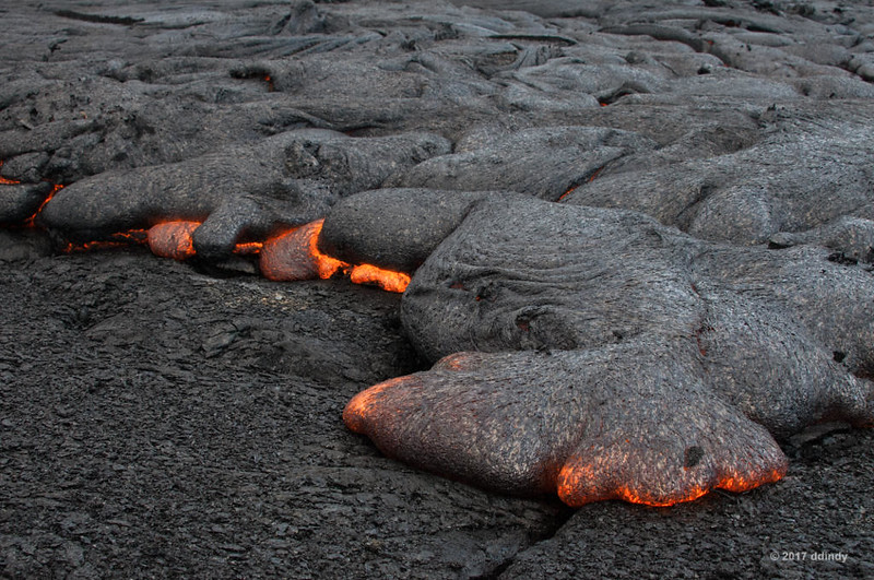
    Lava Hike 1, 6:56 am
     
  2. ddindy

    ddindy Member Staff Member

    It was relatively quiet out here in the middle of nowhere, but the hot lava made a sort of sizzling sound, like meat cooking on a grill.

    [​IMG]
    Lava Hike 1, 6:57 am


    [​IMG]
    Lava Hike 1, 7:00 am


    I was wandering around the perimeter of the flow and took this shot looking down into a crack. Leaving the spot, I noticed loose flakes of lava sticking to my boot soles. The ground was a little warmer than I thought.

    [​IMG]
    Lava Hike 1, 7:08 am


    Here's what my boots looked like as a result.

    [​IMG]
    The Aftermath


    Even though the surface looks cool and solid, danger lurks beneath.

    [​IMG]
    Lava Hike 1, 7:18 am


    This video shows an interesting phenomenon: As the lava moved forward, small flakes of lava from the underlying surface are flicked into the air. (Click the photo below to view the video.)

    [​IMG]
    Lava hike 1 video, 7:19 am


    Another tour group, from Kalapana cultural tours, found our secret lava spot. They were the only other people we saw on the lava that day.

    [​IMG]
    Lava Hike 1, 7:22 am


    (Click the photo below to view the video.)

    [​IMG]
    Lava hike 1 video, 7:23 am


    Another sign of the ground's flatness is the width of flow.

    [​IMG]
    Lava Hike 1, 7:27 am


    About this time, a light shower passed through. It was interesting to hear the rain drops hiss as they hit the hot lava and instantly evaporated (you can hear it at the 1:00 point in the video). (Click the photo below to view the video.)

    [​IMG]
    Lava hike 1 video, 7:34 am


    [​IMG]
    Lava Hike 1, 7:37 am


    The first wave of tourist helicopters showed up, buzzing around like angry hornets. Yvonne said it was time to head back. Once back at the access road, the three of us took a short walk over to where we could see the point where the lava flows into the ocean. We couldn't see any actual lava from here as it was flowing underground. The rope in the foreground is all that prevents people from walking into dangerous areas. The fresh lava is not very stable, and frequently slides into the ocean. A big chunk of land along here disappeared at the end of 2016.

    [​IMG]
    Growing Island
     
  3. ddindy

    ddindy Member Staff Member

    Five hours and eight miles later, we returned to the car. It was hard work, and thanks to my melted boot soles, the hike back was fairly uncomfortable. Yvonne thoughtfully had a cooler of cold juice in her car, and as we chatted she mentioned that on Sunday she would be making an even earlier hike to photograph the lava before dawn. Would I like to come along? You bet! All I need to do is find a new pair of hiking boots.

    Here's a map showing the route of our hike. Yvonne sent me a copy of the data from her GPS tracker and I imported it into Google Maps. The numbers on the map are mile markers. The lava was at mile 4, and the little loop at mile 6 was our side trip to the ocean entry.

    [​IMG]
    Lava hike 1 route


    Google's satellite photo must be a few years old, because the plume of steam in their photo is nowhere near where it is today. It's an ever-changing landscape.

    Due to road construction, there was a massive traffic backup on the road from Kalapana to Kea'au. It was especially bad because there are no alternate routes in the area. Once we finally made it to Kea'au (around 11:30 am), we stopped for lunch. On the way back to the condo, stopped at the Volcano Winery to sample their wares. The rest of the day was spent resting up from the day's activities and making plans for Saturday. We were exhausted!

    Yvonne likes to post photos of her hikes on Facebook. Here are the photos from my Friday hike. (You may be required to log on to Facebook to view them.)

    You don't need log on to see her compilation of time-lapse videos from that day:


    In part 7, we take a break from the bleak volcanic landscape.
     
    Joanie Eddis-Koch likes this.
  4. ddindy

    ddindy Member Staff Member

    To give you something to look at while I'm working on part 7 of my trip report, here are some links for Yvonne Baur:

    Yvonne has gone into business for herself, offering lava photography tours in both English and German. Her web site, www.yvonnebaurphotography.com, is the place to go to book a tour, buy her 2018 lava calendar (highly recommended) or prints of her outstanding photos. Pro tip: If you go to Hawai'i and want to do a lava hike, wait until you're there to book your tour. Lava flows change every day, and there's a chance that there won't be a viewing opportunity during your visit. There's no point in spending money to see nothing.

    Yvonne is very active on Facebook and Instagram, and frequently posts videos to her Youtube channel.

    You can see some of her current and older photos on Smugmug.
     
  5. ddindy

    ddindy Member Staff Member

    Trip report part 7

    Time to stop and smell the flowers

    First off, a big apology for the big gap between parts 6 and 7. In the two months that have passed, I made two trips to Disney World, lost a hard drive in one PC and the power supply in another. Plus I wasted a lot of time simply trying to identify the subjects of the photos in this report before giving up.

    Saturday, August 26 was another day to sleep in since there were no early morning appointments. The first order of business was to find a pair of hiking shoes or boots to replace the pair that were terminally melted by hot ground the day before. The nearest city was Hilo, on the east side of the big island.

    On the way into town, we passed the Mauna Loa macadamia nut plant. We would have stopped at the visitor center for a tour and some free samples had we seen the entrance in time. So we added that to the list for the next trip, whenever that may be.

    The first stop was at the Prince Kuhio Plaza mall, which bore a striking resemblance to every other mall that I've been in. After a thorough search of all shoe stores in the place, I found nothing acceptable. So we went next door to a discount clothing store (Ross) and within minutes found a pair of hiking sneakers in my size for the bargain price of $18! I guess Pele wanted me to come back for another visit.

    One of the must-do places to visit for my sister was the Hawaii Tropical Botanical Garden. I pretended that I was taking her there just to make her stop carrying on about it, but in truth I was looking forward to visiting it myself. I guess the work of the Disney World botanical department had given me a desire to see interesting greenery in other places. (Take a look at the web site. It has a description of the garden, a map of the trails and a plant database with an entry for every type of plant that they have.)

    The garden is several miles north of Hilo on a road that was once the main highway. After driving over it, I'm glad they built a much nicer road. Sure, it's narrow, has many blind corners and several one-lane bridges, but it's a route worth exploring. Sadly, we didn't have the time to do so as we were focused on visiting the Garden.

    [​IMG]
    Welcome to the Jungle


    After parking and purchasing tickets, we went across the road to the garden entrance. The first trail you encounter is a lengthy boardwalk that goes down a hill to the garden area near the ocean. There are several interesting plants along the boardwalk, like this Borneo Red Beehive Ginger.

    [​IMG]
    Borneo Red Beehive Ginger


    At the bottom of the boardwalk, there are several trails, each of which highlights a specific type of plant or scenic location. Some examples are the Palm Jungle, Onomea Waterfalls, Orchid Garden, Anthurium Corner and Torch Ginger Trail.

    It was a beautiful day with lots of interesting plants. I'll just post a sampling here. If you want to see more, look at my Flickr Hawai'i album where I've posted several more photos.

    [​IMG]
    Pauahi Bishop Hibiscus


    [​IMG]
    Cat's Whiskers


    [​IMG]
    Tahitian Double Ginger


    [​IMG]
    Torch Ginger


    The Orchid Garden, as you would guess, contains an astounding variety of orchids. I always thought they were kind of creepy looking, like some sort of alien life form, but seeing so many gave me a new appreciation for their beauty.

    [​IMG]
    Orchid 13:51


    [​IMG]
    Orchid 14:03b


    [​IMG]
    Orchid 14:56


    [​IMG]
    Orchid 13:55


    [​IMG]
    Orchid 14:08b
     
    Last edited: Dec 23, 2017
  6. ddindy

    ddindy Member Staff Member

    They also have a wide variety of Anthuriums, which feature obscene-looking flowers sprouting from pretty leaves.

    [​IMG]
    Anthurium Corner


    [​IMG]
    Anthurium 13:12


    [​IMG]
    Anthurium 14:15b


    [​IMG]
    Anthurium 14:15a


    Eventually we found our way down to the ocean. This area was the site of a village protected by these rocks. Click the photo to read the legend of the twin rocks.

    [​IMG]
    Twin Rocks of Kalahii


    Later, the bay became an important port for trade. Eventually the need for the port dropped off, and later the land was purchased by the founders of the Garden.

    This flower, the Beach Naupaka, also has a legend associated with it. Click the photo read the further adventures of the volcano goddess.

    [​IMG]
    Beach Naupaka


    We spent the better part of the afternoon exploring the garden, so it was dinner time when we left. After consulting our guide book, we decided to dine at the Hilo Burger Joint. It was a hole-in-the-wall bar in a questionable neighborhood, but the food was very good. They had a variety of burgers (and other dishes) that reflect the fusion of western and eastern cultures that is modern Hawai'i.

    Full and satisfied, we headed back to the condo. I went to bed early to get a little sleep before rising in the wee hours for my second lava hike.

    Stay tuned for part 8! (With luck, it will appear after a reasonably short wait.)
     
    Scottwdw, Joanie Eddis-Koch and gary like this.
  7. gary

    gary Member

    if you had not given me some orchids i would have demanded a refund
     
    Joanie Eddis-Koch likes this.
  8. ddindy

    ddindy Member Staff Member

    There's a bunch more on Flickr.
     
  9. gary

    gary Member

    just came back from the flicker, look at you go, you have some very nice flower shots on there
     
  10. ddindy

    ddindy Member Staff Member

    Trip report part 8

    Return to lava

    Sunday, August 27 was, in retrospect, one of the best days of a trip full of great days. As you may recall from part 6, guide and photographer Yvonne Baur invited me to join her on a second hike with the goal of taking pre-dawn photos of lava. Since sunrise was at 6 am and we would have to hike up to four miles to reach the flow, I was up at 1 am and on the road just after 2.

    Approaching the entrance to Hawai'i Volcanoes National Park, the distant glow of Halema'uma'u crater was too much to resist. I pulled off of the road, set up my tripod and took a few quick shots. The sky was incredibly clear (other than the smoke coming from the crater), so you can see a few stars in this shot.

    [​IMG]
    Pele's Cooking Something Up


    I was scheduled to meet Yvonne at the end of the public road in Kalapana in 3:30 am. The photo stop en route only delayed me by five minutes. As before, I transferred my gear to her car and we drove another mile down the road to her special parking spot. We grabbed our backpacks and headed down the access road in complete darkness - we didn't even use flashlights. Again, the sky was very clear and there were no street or house lights visible, so I marvelled at seeing the Milky Way for the first time in years. I would have loved to try to get a photo of it, but we had to press on to be at the lava flow before the sky got too light.

    We headed onto the lava field around 4:15 am. There was still a glow of lava dropping over the edge of Pulama pali in the distance, but it didn't seem to be as bright as it has two days earlier. It felt like we hiked for a longer time than on Friday, but that may just have been my imagination. We could see haze in the distance which marked the location of the lava tube where the bulk of the lava flows underground to the sea, but there was no obvious sign of any surface flows.

    Finally, we topped one of the many hills and saw what we came for.

    [​IMG]
    Lava Hike 2 5:44 am


    We dropped our backpacks in what we thought would be a safe place (we later had to move them a little farther away from the flowing lava), set up our tripods and went to town capturing the ever-changing scene.

    [​IMG]
    Lava Hike 2 5:37 am


    [​IMG]
    Lava Hike 2 5:38 am


    [​IMG]
    Lava Hike 2 5:40 am


    [​IMG]
    Lava Hike 2 5:45 am


    [​IMG]
    Lava Hike 2 5:46 am


    [​IMG]
    Lava Hike 2 5:50 am


    It was interesting to see the various patterns on the cooling surface of the lava. In this photo, the dark ripples have swirled around as the left side moves more slowly than the right.

    [​IMG]
    Lava Hike 2 5:47 am


    Setting the exposure was tricky. There was glowing lava on top of the old dark lava under a brightening sky with some clouds. And since some of the lava was moving, long exposures could end up blurry in spots. Bracketing was the order of the morning.

    The front of the lava flow ended up going in two directions. The main part was following the natural path towards the ocean.

    [​IMG]
    Lava Hike 2 5:54 am


    [​IMG]
    Lava Hike 2 6:04 am


    [​IMG]
    Lava Hike 2 6:15 am


    [​IMG]
    Lava Hike 2 6:49 am


    [​IMG]
    Lava Hike 2 6:54 am
     
    jbwolffiv and Joanie Eddis-Koch like this.
  11. ddindy

    ddindy Member Staff Member

    Off to one side was a hollow that somehow had not been completely filled by previous flows, so quite a bit of lava flowed down into that. In the first photo, you can see how the falling stream of lava moves back and forth on the bottom, much like thick cake batter. You can also see strings of "Pele's hair," threads of hardened lava formed by small drips.

    [​IMG]
    Lava Hike 2 6:31 am


    [​IMG]
    Lava Hike 2 6:33:05 am (1 of 3 in sequence)


    [​IMG]
    Lava Hike 2 6:34:33 am (3 of 3 in sequence)


    [​IMG]
    Lava Hike 2 6:47 am


    One very unusual phenomenon was this tubular stream of lava that grew slowly along the ground.

    [​IMG]
    Lava Snake 1


    It rose up above the ground and appeared to grow a snout.

    [​IMG]
    Lava Snake 2


    It finally came to a halt, frozen in place until it's buried by another flow. It reminded me of that water tentacle thing from The Abyss.

    [​IMG]
    Lava Snake 3


    The tourist helicopters started buzzing around, signaling us that it was time to leave. I posed for the obligatory tourist photo as the skin on my right elbow started to sizzle from the heat.

    [​IMG]
    Lava Hike 2 7:21 am


    In order to save some time, Yvonne suggested that we take a more direct route to the park entrance. It meant a longer hike over lava, but saved about a mile of hiking. That's Yvonne leading me across years of accumulated lava.

    [​IMG]
    Hiking Off Into the Sunrise


    Here's the route of the day's 6.5 mile hike, created using GPS data from Yvonne. If you compare it to the map at the end of part 6c, you can see that the lava we found on the second hike could very well be downstream from what we saw on the first.

    [​IMG]
    Lava Hike 2 Route


    We returned to my car at 9:30 am, six hours after I parked there. I left my cell phone in the car, so I don't have any videos to post. However, I did take quite a few multi-shot sequences, so if I can ever figure out how to combine them into short videos, I'll post them here.

    Here are some of Yvonne's photos from Facebook and her time-lapse video.


    It was a wonderful way to spend a morning. We didn't see another soul while we were on the lava.

    I thanked Yvonne for the hike, bought a calendar featuring her lava photos, and headed back to the condo. Once there, I took a short nap, did laundry and packed for the next day's travel.

    My sister and I strolled down the road to Punalu'u Black Sand Beach. The beach is lava ground down to sand by the constant pounding of waves from the Pacific. Sea turtles are often seen here, but since this was a busy Sunday, they stayed in the water.

    [​IMG]
    Punalu'u Black Sand Beach


    In case you're curious, here's the view from the upstairs balcony of our condo. It was fun to just stand there and watch the swaying palm trees and the waves breaking over the rocks in the distance.

    [​IMG]
    View from Sea Mountain condo


    That evening, we drove back to Hawai'i Volcanoes National Park. One of the things we booked in advance was dinner in the restaurant at the Volcano House hotel. Our plan was to have a sunset dinner at a window table overlooking Kilauea crater, enjoying the glow of lava in the bottom of Halema'uma'u. Unfortunately, some clouds rolled in, completely blocking the view. I finally asked our server if they would please turn the volcano back on for us. :D 
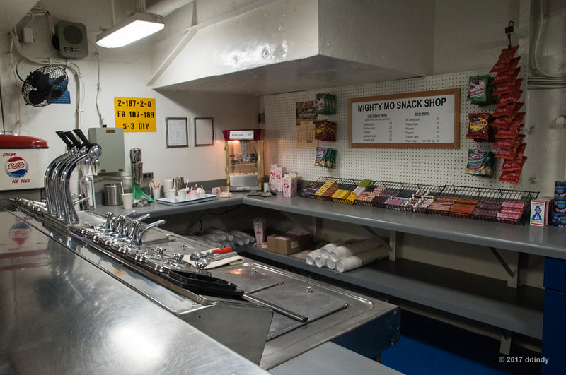
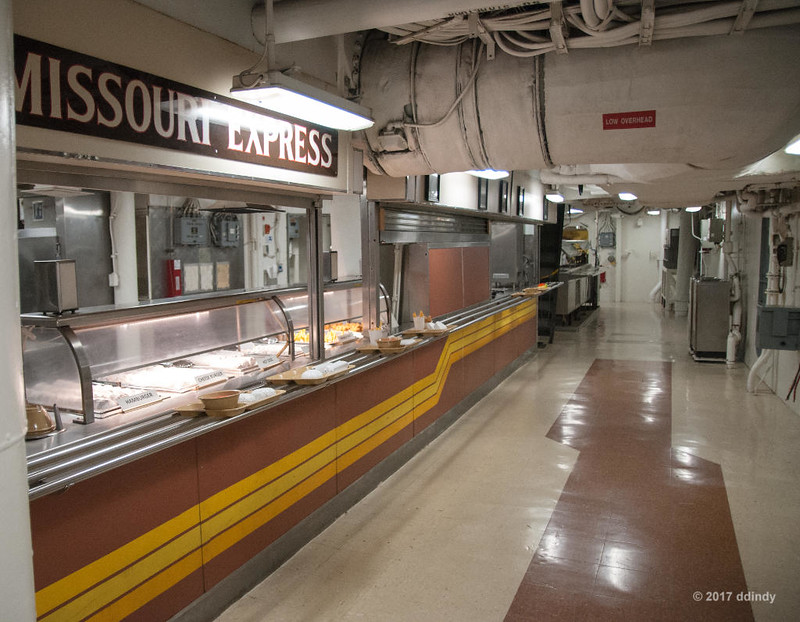
At least the food was good.

    After dinner, the clouds thinned and we went to the observation area on the other side of the crater. The view was much better than what we had at dinner.

    [​IMG]
    Steaming Halema'uma'u


    Looking through my sister's Nikon P900 superzoom with its 24-2000 mm equivalent lens, it was possible to see lava splashing on the side of the crater as gas bubbles burst on the surface of the lava lake that is just out of view.

    That pretty much wrapped up our activities on the island of Hawai'i. As always, there are more photos from this day in my Hawai'i album on Flickr.

    Part 9 should be along pretty soon because it will be fairly short. Stay tuned!
     
    Last edited: Jan 1, 2018
  12. ddindy

    ddindy Member Staff Member

    Trip report part 9

    Travel Break

    Monday, August 29 was spent changing islands. We left Sea Mountain around 9 am for the two-hour drive over winding roads back to Kona. As we got to Kona I missed the turn onto the bypass, so we ended up going up Ali'i Drive along the ocean and past the site of our 2006 visit, Sea Village Condos, a sister resort to this trip's Sea Mountain lodging. Neither has air conditioning, which is apparently normal in Hawai'i. Braving the slow tourist traffic in downtown Kona, we eventually made it to the airport with time to spare.

    The Kona airport is rather unique in that there are no closed buildings - it's a collection of open-air huts. You go to the check-in hut to get your bags tagged, then drop them off at the TSA X-ray machine. The security hut is rather closed-in and hot. Everyone uses the single metal detector, but if you're Pre-Check they give you a yellow card that's like a FastPass to let you through ahead of the rabble. Then you go wait for your flight in the open-air waiting hut. At boarding time, you walk out onto the tarmac and up a ramp onto your plane. (No more stairs up to the plane; too many roller bags, I guess.)

    Inter-island flights are very short - so short that your serving of lilikoi juice comes pre-packaged in a small plastic cup so the flight crew doesn't have to waste time filling them.

    Once we landed in Honolulu, it seemed like we taxied for a period of time equal to the flight from Kona. Too bad we were taxiing west but our lodging was to the east.

    We picked up our rental car and headed for Waikiki. I missed the ramp onto the freeway (I hesitate to call it an Interstate since it stays entirely on the island of Oahu), so we took the Nimitz Highway, a long drive with lots of traffic through the big city.

    After fighting the poor layout of one-way streets in Waikiki that made it seem almost impossible to get from where you were to where you wanted to be, we finally got to our destination, the Fairway Villa condos at the corner of Walina Street and Ala Wai Blvd. They didn't have a two-bedroom unit so we ended up in two studios, my sister on the 12th floor and me on the 16th. The rooms were slightly bigger than a Disney moderate room. They had a compact washer and dryer next to the bathroom, a kitchen area, a Murphy bed and a small pull-out couch. There was also a small air conditioner, though not a very good one. Not a great arrangement, but it was good enough for the two nights we would be there.

    I stepped out onto the narrow balcony and took a 180-degree panorama of the view. (Click the photo for a larger image.)

    [​IMG]
    Waikiki Panorama


    North is to the left, Diamond head is just visible behind the buildings left of center and Waikiki Beach is behind the buildings on the right. Lovely, isn't it?

    Here's a full image looking to the north. If you look closely at the highrise on the left, you can just barely make out a rainbow in the hills behind it. It was the second rainbow of the trip and not the last.

    [​IMG]
    Oahu Rainbow


    We tried to decide where to eat and finally just headed toward the beach to see what we could find. We stopped at the International Marketplace, which in the past was a big open-air market. Now it's just another multi-story shopping mall. My sister stopped at one of the fancy shops to buy some special shampoo and asked the folks there for a dining recommendation. One of the places they mentioned was a beer-and-pizza place called Flour & Barley. Since beer and pizza cover all of the necessary food groups, we decided to try it out. It was pretty good.

    After dinner we walked through the Royal Hawaiian Hotel, the most famous hotel in Waikiki. It was pretty impressive. We finally reached the beach just after sunset and took in the view as the sky darkened. We also watched a bit of the Royal Hawaiian Luau; the stage is right next to the beach, so we had a good view of the Samoan fire dancers and the twitchy-hipped Tahitian girls.

    We decided to call it a night and took the public access route from the beach. This turned out to be an alley with hundreds of surfboards stored against the walls of the buildings on either side. It was an impressive sight to this boy from the Midwestern flatlands.

    Stay tuned for part 10: The bowels of Mighty Mo.
     
    mSummers and Joanie Eddis-Koch like this.
  13. ddindy

    ddindy Member Staff Member

    Trip report part 10

    The Bowels of Mighty Mo

    It's Tuesday, August 29, and we're on Oahu in the cityscape that is Waikiki. Our sole purpose for visiting Oahu is to take in all the sights of the Pearl Harbor historic sites.

    There are four historic sites to visit. The World War II Valor in the Pacific National Monument (including the USS Arizona Memorial) and the USS Bowfin Submarine Museum and Park are right next to the parking lot. The other two sites, the Battleship Missouri Memorial and the Pacific Aviation Museum, are on Ford Island and require a short shuttle bus ride.

    As part of our advance planning, we decided to pre-purchase tickets to the three sites that required them (the national monument is free) and visit Ford Island on the first of the two remaining days we had in Oahu. We upgraded our Missouri experience by booking the Heart of the Missouri tour, which promised to take us into parts of the ship that the are off limits to those with regular admission.

    Our tour started at 9 am with a recommended check-in at 8:30, so we left plenty early to travel the 12 miles from our condo to Pearl Harbor. If you don't know about Honolulu traffic, I'll just say that most of the people living in that part of Oahu must have moved there from Los Angeles, because they seem to love sitting in slowly-moving freeway traffic. Our journey started by taking what seemed like forever just to wind through some back streets to get on the freeway. Once there, traffic crawled most of the trip with only occasional chances to move at speeds over 40 mph. And to top it all off, since we arrived at the memorial around 8 am, there was a final traffic jam of commuters heading to Ford Island. I don't recall what our travel time was, but it was waaaaay too long.

    Since we arrived so early, parking was not a problem. We checked in and picked up our Missouri tickets, then walked a short distance to board the luxurious shuttle bus. (Seriously, it was one of those really nice tour buses, similar to the those used by Disney Magical Express.) Since we were the only people crazy enough to be there that early, we were the only passengers on the bus and had plenty of time to chat with the driver as we sat in the traffic heading to Ford Island.

    Once at the Missouri, we took a quick pass through the gift shop then boarded the ship and checked in for our tour. Once again we were the only people on the tour. Our guide, Andy, took us into the Officers' wardroom to introduce himself and give us some background. He served in the Navy, and while he didn't serve on the Missouri, he was on the USS Bunker Hill in the late 80s which sailed alongside the Missouri as part of Battle Group Echo.

    The Missouri was commissioned in June, 1944, decommissioned in February, 1955, recommissioned in May, 1986 and finally decommissioned in March, 1992. It served in WWII, the Korean war and the Gulf war. On September 2, 1945, Japan signed the instrument of surrender on the Missouri's deck. The ship was docked at its current location in Pearl Harbor on June 22, 1998 and has been open to the public for nearly 20 years.

    [​IMG]
    Permanent Mooring


    Unfortunately, the ship's upper decks were surrounded by scaffolding as they were getting a fresh coat of paint. As a result, they were off limits to visitors.

    You can read the ship's vital statistics for yourself, but one item that stood out to me was hearing that the ship's width of 108 feet was limited by the 110-foot width of the Panama Canal locks of the 40s. Kind of a tight fit!

    We went back out on deck and climbed up into the turret officer's booth at the back of the front gun turret. I've always been fascinated with the mechanism and manpower required to fire these 16-inch guns every thirty seconds, so it was a treat to get to look inside at what makes it all tick.

    [​IMG]
    Big Guns (forward)


    On the deck there is a display showing one of the 16-inch shells alongside a powder can with the side cut open, showing one of the three 110-pound bags of black powder held by each can. It took six bags to fire each shell.

    [​IMG]
    Big Bullet for a Big Gun


    Sadly, my photos from inside the turret were less than satisfactory. In place of that, here are links to some YouTube videos: A 1955 training film, a video from 1988 showing one of the guns being fired and reloaded, and a recent video tour showing an identical turret on the USS Iowa (on display in Los Angeles). The latter video starts at the bottom of the turret and at minute 11 has finally worked its way up to the booth that we were allowed into.

    Leaving the turret, we went down to the third deck. This is two decks below the main deck. We entered between turrets 1 and 2, walked around the cylindrical base of turret 2 and took a stroll down "Broadway," a passage that runs the length of the ship between turrets 2 and 3.

    [​IMG]
    On Broadway


    There are a variety of rooms off of the central corridor. For the most part, we were only allowed to look into those rooms. Then things got interesting as we got to see what made the ship go. First stop was a firing room, which has nothing to do with shooting things but rather is where the fire is that heats the water in one of the eight boilers. Next, we went into a boiler room where we learned that the ship uses a closed-loop steam system: the boiler turns water into steam which passes through high and low pressure turbines and then is condensed back to water, beginning the cycle again. Our propulsion tour concluded in the turbine room, where we saw the controls that set the speed of the turbines which in turn control the speed of one of the ship's four screws.

    [​IMG]
    Turbine Throttles


    Back up on deck 3 we saw some of the sturdy analog computers used to control the 16-inch guns in the aft fire control room.

    [​IMG]
    Reliable Computer Technology


    One of the perks of the tour is the opportunity to "fire" the big guns. Nowadays, the trigger just starts a video recording that, just like in real life, fires the guns five seconds after the trigger is pressed.

    [​IMG]
    What Does This Button Do?


    Soon after this we returned to daylight on the main deck behind turret 3 and said farewell to Andy. We headed forward and joined one of the guided tours of the main deck. This highlight of this tour is the Surrender Deck where, on September 2, 1945, Japan signed the instrument of surrender to end World War II.

    We also learned about the day in 1945 when a Japanese Kamikaze pilot crashed into the side of the ship.

    [​IMG]
    Kamikaze Reminder


    The only casualty was the pilot. In what was at the time a controversial move, the ship's captain insisted on giving the enemy pilot a proper burial at sea with full military honors.

    We headed down to deck 2 to take the self-guided tour of that deck. Here are a few of the things we saw:

    The snack bar.

    [​IMG]
    Chocolate Soda, Please


    One of two cafeteria-style grab & go stations.

    [​IMG]
    Cafeteria Line


    The galley.

    [​IMG]
    Cooking for Crowds


    Some 1980s-vintage bunks.

    [​IMG]
    Modern Bunks


    Having seen as much of the Missouri as we could, we rode the shuttle bus a short distance to the Pacific Aviation Museum. The museum is housed in two hangars and has several outdoor display areas.

    Hangar 37 is the first building we visited. It contained several informative displays and dioramas such as this one simulating the deck of the USS Hornet and one of the B-25 bombers of the Doolittle Raid on Tokyo.

    [​IMG]
    Doolittle Raider


    We then moved over to Hangar 79, passing the control tower on the way. The tall red and white tower was still under construction in December, 1941. The building is not yet open to visitors, but you can see the F-105 and Sikorsky Sea Stallion on display.

    [​IMG]
    Ford Island Tower


    Speaking of December 7, 1941, these bullet holes in the windows of Hangar 79 have been preserved to remind us of the horrors of that fateful day.

    [​IMG]
    Gifts from Japan


    Hangar 79 contains a variety of aircraft on display. One of the more interesting is this B-17E that crash landed in a New Guinea swamp in 1942. It remained there until it was retrieved in 2006, gaining the nickname Swamp Ghost.

    [​IMG]
    Swamp Ghost


    Some of you may know that during World War II, artists at the Disney Studios created logos and nose art for all branches of the U.S. military. They are reviving that practice in the 21st century, creating a one-off design for the Swamp Ghost.

    [​IMG]
    New Nose Art


    (Could this be in any way related to the fact that Disney's Aulani resort is just over ten miles west of the museum?)

    Reluctantly, we boarded the shuttle bus back to the Arizona Memorial and our car. There had been light rain off and on all afternoon, and it started raining more heavily as we left the parking lot. Our plan was to attend Germaine's Luau on the southwest corner of the island. We got on the freeway and sat in the slow-moving traffic of the evening rush hour. The heavy rain and questionable wipers on our car did nothing to make the expierience any better. When we finally got to Barbers Point, we were told that the luau had been cancelled, so we turned around and headed back to Honolulu. The rain was ending, providing a nice rainbow. But as we got back to Honolulu, we found even more slow traffic! Oh, how I learned to hate driving in Oahu.

    For dinner we headed back to Flour & Barley where my sister and I both dined on some delicious Teriyaki Salmon to end the day.

    As always, you can see more photos in my Hawai'i album on Flickr. I also recommend visiting the official sites of the Battleship Missouri Memorial and the Pacific Aviation Museum. You can find a plethora of videos about the Missouri and her sister battleships Iowa, New Jersey and Wisconsin on YouTube.

    Next comes part 11, Arizona, Bowfin and Aloha.
     
    mSummers and Joanie Eddis-Koch like this.
  14. ddindy

    ddindy Member Staff Member

    Trip report part 11

    Arizona, Bowfin and Aloha

    Wednesday, August 30 was our final day in both Honolulu and Hawai'i. We didn't have to get up terribly early, but I did anyway so I could pack and be ready to head back to Pearl Harbor. As a result, I had time to kill in the condo until the departure time that my sister and I agreed upon.

    Our plans for the day were to visit the USS Arizona Memorial first, followed by the USS Bowfin Submarine and Museum. We purchased our Bowfin tickets on-line in advance. Admission to the Arizona Memorial is free, but you have the choice of reserving a ticket up to 60 days in advance or taking a chance on one of the 1300 same-day tickets that are released daily at 7 am. We chose the "FastPass" route, and also pre-purchased the audio tour.

    Our tickets for the boat ride to the Arizona were for 1 pm, so we figured that arriving around 10 am would give us plenty of time to visit the museum and grounds before getting on the boat. Fortunately, this allowed us to miss the nightmarish traffic we encountered the day before. Unfortunately, due to the small size of the parking area at the memorial (which serves all four Pearl Harbor historic sites), we were reduced to circling the parking lot like Christmas shoppers, waiting for someone to leave.

    When we checked in, they offered us the opportunity to take an earlier boat to the memorial, so we traded our 1 pm tickets for 11:30 am. This cut short our morning museum time, but we knew we would have time to see everything before we headed for the Bowfin.

    The World War II Valor in the Pacific National Monument features two museums ("Road to War" and "Attack"), a theater, snack shop, gift shop, several outdoor exhibits and a new virtual reality experience. The outdoor exhibits include the Arizona's bell and one of its anchors as well as spots for remembrance and contemplation.

    After picking up our audio tour playback devices, featuring narrations read by Jamie Lee Curtis, we visited the Road to War Museum. The exhibits in this building describe what things were like in 1941 Oahu. There are also model ships and areas describing the state of mind of both the United States and Japan, giving one a feel for what both countries were thinking shortly before the "date that will live in infamy."

    Since it was nearly 11 am, we went to the theater where we saw a short film telling about the attack on Pearl Harbor. The end of the film reminded everyone that the Arizona Memorial is a place that honors those who lost their lives on December 7, 1941 and therefore should be treated with respect. (It's a shame that some people have to be told that.) After the film, everyone headed out to board a boat for the short ride to the memorial.

    [​IMG]
    The Beginning and the End


    Near the center of the memorial, there is a diagram showing the Arizona while still in service and another showing her in her final resting place.

    [​IMG]
    Arizona Memorial Orientation


    At the time of the attack, seven ships were moored in pairs at mooring quays like this one. They were easy targets for the Japanese planes. The large round object on the right is the base the third of Arizona's four gun turrets.

    [​IMG]
    Reminders of War


    There is a dedication plaque with the following inscription:

    Dedicated to the eternal memory of our gallant shipmates in the USS Arizona who gave their lives in action
    7 December 1941
    "From today on the USS Arizona will again fly our country's flag just as proudly as she did on the morning of 7 December 1941.
    I am sure the Arizona's crew will know and appreciate what we are doing."
    Admiral A. W. Radford, USN
    7 March 1950
    May God make his face to shine upon them and grant them peace.

    [​IMG]
    Grant Them Peace


    If you look closely just to the left of the white flagpole, you can see a small white object in the water. It marks the stern of the Arizona. There is a similar one marking the bow that is visible in this photo of the USS Missouri that I included in part 10:

    [​IMG]
    Permanent Mooring


    Our allotted time passed quickly, and before we knew it we were told to prepare to board the boat for the return trip. This was kind of a surprise for me, as I thought we would be allowed to stay as long as we liked. Obviously, with such a small area and high demand, it makes sense to limit visits to the time it takes for the boat to make a round trip.

    If you are curious about the design of the memorial, there is a plaque on the shore telling about it and its architect. Ironically, architect Alfred Preis moved from Austria to Hawai'i in 1939 to escape the Nazis.

    [​IMG]
    Honor


    Back on dry land, we grabbed lunch from the snack shop and then visited the Attack Museum. The exhibits here include a model of a Japanese "Kate" torpedo bomber and an exhibit showing the radar station on the north side of Oahu (along with the story of why the operators were told to ignore the incoming planes that they saw). There is a small theater showing a film of the attack and exhibits showing the work to salvage the ships that were not irreparably damaged.

    One of the most moving exhibits was a video of interviews with people who were in Pearl Harbor and surrounding areas during the attack. Some were people of Japanese ancestry who worked at the base and some were just children at the time. Their stories were fascinating.

    As you may know Hawai'i is a popular vacation spot for Japanese tourists. I was very curious to know what the young Japanese visitors thought of the exhibits and memorial, but never had the courage to ask. Was this something that has special meaning to them because their parents or grandparents were directly affected by (or participants in) the war? Or, like young Americans, was it just something they studied in history class and don't really relate to?

    We walked the short distance to the USS Bowfin. This submarine was launched on December 7, 1942 and thus was nicknamed the Pearl Harbor Avenger.

    [​IMG]
    Visitors Welcome


    Admission to the submarine and museum included a narrated audio tour. It provided fascinating facts and stories about the submarine and its patrols. In this photo of the forward torpedo room, you can see numbers posted that are keyed in to the audio player. One number is for the adult narrative and the other is family-oriented (which is a fancy way of saying "child friendly.")

    [​IMG]
    Forward Torpedo Room


    Space is tight on a submarine. Sometimes your bunkmate is a torpedo. I later learned that when the boat left on patrol, all ten torpedo tubes (six forward, four aft) were loaded and an additional 14 torpedoes were stashed in the two torpedo rooms, giving a total of 24 torpedoes.

    [​IMG]
    Strange Bedfellows


    For comparison, here is the forward torpedo room of Germany's U-505 submarine on display at the Chicago Museum of Science and Industry. It is also cramped and shares bunk space with the torpedoes.

    [​IMG]
    A yellow submarine it's not


    The Bowfin's main control room featured an array of switches and valves.

    [​IMG]
    Fuses, Switches and Valves


    The rudder control is located on the forward wall of the control room.

    [​IMG]
    Steering Wheel


    To left (port) of the rudder man are the dive plane controls.

    [​IMG]
    Dive Controls


    In the stern, between the four diesel engines and the aft torpedo room, the engineer controlled the motors connected to the screws based on the signals sent from the control room via the telegraph on the upper left.

    [​IMG]
    Engineering Station


    Back on deck, we took a last look at the USS Missouri and the Arizona Memorial before heading in to the museum.

    [​IMG]
    Ever Vigilant


    The museum features a wide variety of exhibits about the history of the submarine service, past and present. It was all very interesting. Sadly, it was nearing closing time so we were a little rushed but managed to at least take a quick look at all of the exhibits.

    When my sister booked our Hawai'i flights, she originally had us on a direct flight from Honolulu to Portland, leaving at 10:30 pm. Sadly, Alaska juggled their schedules and switched us to a 12:25 pm flight. That would have meant no time for most of our plans for August 30, so she changed us to a midnight flight via Seattle. Since everything at Pearl Harbor closed at 5 pm, we had plenty of time to kill and ended up going to a movie theater to see The Hitman's Bodyguard.

    After the film, we took our time heading back to Honolulu airport where we returned the rental car and checked our bags. Dinner was at the airport food court because neither of us was in the mood for a heavy meal.

    Midnight found us in our first-class seats on our Alaska Airlines flight to Seattle. The good news was free booze (and they weren't skimpy; I asked for Woodford Reserve bourbon and they gave me a glass and TWO bottles). The bad news was that there was a continuous flow of snacks during the night, meaning that it was impossible to get much sleep.

    Seattle was overcast and damp on the last morning of August (no surprise there), and we spent the layover in the Alaska Airlines first-class lounge watching airplanes. Seattle has three parallel runways, so planes landing on the west runway sometimes had to sit waiting for traffic to clear on the center and east runways. Thanks to the high humidity, every plane taking off had clouds of condensation over the wing tops as the plane rotated upwards. It would have made great photos, but I was too tired to dig my camera out.

    Our flight to Portland was on a twin-engine Horizon Air turboprop. Once we worked our way to the front of the long line of departing planes and took off, the short trip to Portland was uneventful. The only real problem was that when I retrieved my checked bag I discovered that the handle had been broken by one of those gorillas assigned to baggage handling. You'd think a first-class ticket would rate first-class baggage handling.

    After a few more hours we were back at my sister's house in Lincoln City, looking forward to a day of relaxation and recovery.

    As always, you can see more photos in my Hawai'i album on Flickr. I also recommend visiting the official sites of the World War II Valor in the Pacific National Monument (including the USS Arizona Memorial) and the USS Bowfin Submarine Museum and Park.

    The final installment is coming soon. Watch for Spouts and Telephones.
     
    Last edited: Apr 7, 2019
  15. ddindy

    ddindy Member Staff Member

    Trip report part 12

    Spouts and Telephones

    Friday, September 1 was another typically chilly day on the Oregon coast. Not horribly cold but cool and windy. Fortunately, the sky was clear for the day's adventure.

    We headed south towards the town of Newport. It's a trip my sister makes fairly regularly, mainly because it's the nearest town with most of the big box stores. It's also a very scenic drive down the coast, so we planned to do some sightseeing.

    Our first stop was less than ten miles south of her house, at the Boiler Bay State Scenic Viewpoint. Boiler Bay earns its name from the action of the waves coming in to the relatively small bay. Much of the Oregon coast is fairly rugged. I'm always impressed by the sight of waves crashing against the rocks.

    [​IMG]
    Rocks near Government Point


    But we weren't there just to look at waves and rocks. Aye, matey, we be huntin' whales!

    Most of the population of Gray Whales migrate up and down the coast, spending summer in Alaska and winter in Baja California. The southward migration wouldn't occur until December, but a small number of whales can be seen at just about any time of year. I hadn't seen any on my previous trip in 2009, so I hoped I would have a little more luck in 2017.

    After exploring the grounds of Government Point (upon which the viewpoint sits), we finally saw a spout. There was a whale a few hundred feet off shore.

    [​IMG]
    Gray Whale Feeding near Government Point


    After a short time we moved further south in hopes of spotting more whales. We passed through the scenic seaside town of Depoe Bay, site of a whale watching center operated by Oregon State Parks, and stopped at Rocky Creek State Scenic Viewpoint. (My, they have a lot of State Scenic Viewpoints in Oregon.)

    We got lucky again. There were several kelp beds nearby. Gray whales feed on the shrimp that gather in and around the kelp beds. This meant another whale, or maybe more - we only saw one at a time.

    [​IMG]
    Gray Whale Feeding near Rocky Creek


    My sister told me that the whales have a habit of surfacing for air three times in relatively quick succession and then disappearing. I assume this is like someone who is preparing to go under water, and wants to get as much fresh air into their lungs as possible in preparation for the dive.

    [​IMG]
    Gray Whale Spout near Rocky Creek


    There were several other people enjoying the whale show. While I was pleased to finally see some whales, some of the other people got very excited. My sister said she always has to laugh at the really excited people, much as we laugh at those who get really excited about seeing Cinderella Castle. Our happy place is a Disney park, her happy place is a humpback whale sanctuary in the Atlantic. She makes a trip there almost every year to join with like-minded folks to snorkel with the humpbacks. So for her, the mere sight of a whale spout or the back of a whale is nothing when you've seen things like this:

    [​IMG]
    Humpback mother and calf
    by Diane Dunkman

    We headed a short distance further south to the Otter Crest State Scenic Viewpoint, high atop Cape Foulweather. Looking south along the coast from the viewpoint you can see the location of the Devil's Punchbowl (the second nearest outcrop), and in the distance, Yaquina Head.

    [​IMG]
    View from Otter Crest


    The viewpoint's elevation is 500 feet above sea level. It didn't seem so high until a plane flew by at pretty much the same altitude.

    [​IMG]
    Flying Tourists


    Cape Foulweather was the first location named by Captain James Cook on his voyage of 1778. The name was inspired by the stormy weather on the March day that he visited the area.

    We dropped back down to sea level and headed to Newport. After a stop to see about getting my glasses repaired (fortunately I always carry a spare pair) and do a little shopping, she took me to a little shop that she thought might interest me.

    The Olde Telephone Company is a shop dedicated to old telephones. They have several rooms full of phones of all types, some dating back to the late 1800s. I think we spent well over an hour taking it all in. Almost everything is for sale, too. I found a nice 1970s vintage Trimline phone that I liked and strongly hinted to my sister that it was getting close to my birthday. She took the hint, and now it sits next to my bed, weighted down by solid metal construction, complete with a real bell.

    If you love phones like this but you've given up the reliability, low cost and decent audio quality of a landline in favor of a lousy-sounding, signal-losing, overpriced cell phone, never fear. They will sell a device from Xlink that connects a Real Phone to your cell phone via BlueTooth. You can make and receive calls just like your grandparents did.

    After all of that excitement, we headed back home so I could pack and get ready for my trip back to Indiana. The clear skies persisted through sunset, so I took one last photo of Siletz Bay from her deck.

    [​IMG]
    Siletz Bay at Dusk


    The next morning my sister drove me to Portland to catch my flight home. While waiting for the flight, I discovered that Portland's House Spirits Distillery had a shop in the airport. I sampled (and enjoyed) their single malt whiskey. Now I have another reason to make a return trip!

    My Southwest flight pulled back on time, and after lifting off, the plane flew a complete circle before heading east. I can only assume that was done to gain altitude before passing Mount Hood, the dormant volcano 50 miles east of Portland. The rest of the flight was uneventful and I arrived in Indianapolis late Saturday evening, 15 minutes early.

    I was sad that the trip was over, but happy with all of the wonderful memories. I was also glad it was Labor Day weekend so I had an extra day to try to get my body back on Eastern time.

    You can see more photos in my Oregon Coast 2017 Flickr album.

    That ends my report. Hope you enjoyed it.
     
    mSummers and Joanie Eddis-Koch like this.
  16. I did enjoy reading your trip report. Thank you for taking the time to write it up and share it with us.
    ~Joanie
     
  17. ddindy

    ddindy Member Staff Member

    My sister sent me some more information on her photo of the humpback whale that I included in part 12 of my report. I thought some of you might find it interesting.

    Interesting that you chose the photo of the mother whale that was upside down the 2 hours we were with her. The most unusual whale I’ve seen. No one had ever seen that before or since nor has anyone I’ve brought it up to. She would gracefully fold in 1 pec fin and roll over to come up to breathe, go back down, fold in a fin and roll over again. Poor calf kept trying to snuggle up under her, but instead of her soft pleats, it was her back! Maybe she had an upset tummy, maybe she didn’t want the whale that was hanging around breeding with her or had just impregnated her, maybe she didn’t want the calf to feed for a while, maybe she was just having a spa day! Not the normal whale situation.
     
    Joanie Eddis-Koch likes this.
  18. Kilauea is having an eruption! Aren't you glad you're not there now!!!

    ~Joanie
     
  19. ddindy

    ddindy Member Staff Member

    Yes, yes I am. The main flow that I hiked on is all but shut down; Pele is poking her fingers into the Leilani Estates subdivision. It's interesting to watch from a distance...
     
    Joanie Eddis-Koch likes this.

Share This Page